


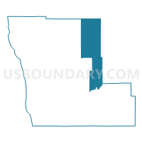
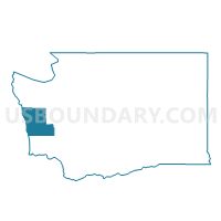
Simpson Voting District, Grays Harbor County, Washington
About
Outline

Summary
| Unique Area Identifier | 684361 |
| Name | Simpson Voting District |
| County | Grays Harbor County |
| State | Washington |
| Area (square miles) | 236.05 |
| Land Area (square miles) | 233.27 |
| Water Area (square miles) | 2.78 |
| % of Land Area | 98.82 |
| % of Water Area | 1.18 |
| Latitude of the Internal Point | 47.31094850 |
| Longtitude of the Internal Point | -123.58599590 |
Maps

Graphs
Select a template below for downloading or customizing gragh for Simpson Voting District, Grays Harbor County, Washington


Neighbors
Neighoring Voting District (by Name) Neighboring Voting District on the Map
- Voting District 601, Jefferson County, WA
- Brady Voting District, Grays Harbor County, WA
- Cushman Voting District, Mason County, WA
- Humptulips Voting District, Grays Harbor County, WA
- Lilliwaup Voting District, Mason County, WA
- Matlock Voting District, Mason County, WA
- Montesano 602 Voting District, Grays Harbor County, WA
- Potlatch Voting District, Mason County, WA
- Quinault Voting District, Grays Harbor County, WA
- Satsop Voting District, Mason County, WA
- Wishkah Voting District, Grays Harbor County, WA
- Wynoochee Voting District, Grays Harbor County, WA
Top 10 Neighboring County Subdivision (by Population) Neighboring County Subdivision on the Map
- Montesano CCD, Grays Harbor County, WA (6,773)
- West Mason CCD, Mason County, WA (6,467)
- Wishkah CCD, Grays Harbor County, WA (1,448)
- West End CCD, Jefferson County, WA (881)
- Neilton CCD, Grays Harbor County, WA (618)
Top 10 Neighboring Place (by Population) Neighboring Place on the Map
Top 10 Neighboring Unified School District (by Population) Neighboring Unified School District on the Map
- Montesano School District, WA (8,042)
- Hood Canal School District, WA (5,908)
- Mary M. Knight School District, WA (1,428)
- Brinnon School District, WA (1,250)
- Lake Quinault School District, WA (1,187)
- Wishkah Valley School District, WA (835)
- Queets-Clearwater School District, WA (629)
- Satsop School District, WA (576)
Top 10 Neighboring State Legislative District Lower Chamber (by Population) Neighboring State Legislative District Lower Chamber on the Map
Top 10 Neighboring State Legislative District Upper Chamber (by Population) Neighboring State Legislative District Upper Chamber on the Map
Top 10 Neighboring 111th Congressional District (by Population) Neighboring 111th Congressional District on the Map
Top 10 Neighboring Census Tract (by Population) Neighboring Census Tract on the Map
- Census Tract 4, Grays Harbor County, WA (6,773)
- Census Tract 9602, Mason County, WA (5,743)
- Census Tract 3, Grays Harbor County, WA (3,334)
- Census Tract 9507.02, Jefferson County, WA (2,131)
- Census Tract 9601, Mason County, WA (724)
Top 10 Neighboring 5-Digit ZIP Code Tabulation Area (by Population) Neighboring 5-Digit ZIP Code Tabulation Area on the Map
- 98520, WA (23,814)
- 98541, WA (10,101)
- 98563, WA (8,001)
- 98548, WA (2,193)
- 98575, WA (228)
- 98560, WA (142)